About This Book
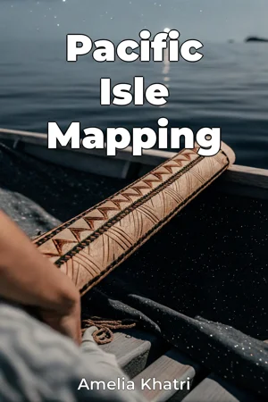
How did ancient mariners navigate the vast Pacific Ocean, charting courses across thousands of miles of open water long before the advent of modern technology? This book, *Pacific Isle Mapping*, delves into the rich history of Pacific navigation and island mapping, exploring both the empirical maritime records left by European explorers and the sophisticated, often overlooked, indigenous navigation techniques. Examining the intersection of these two distinct navigational traditions reveals a complex story of exploration, cultural exchange, and the evolving understanding of the Pacific world. A central focus will be placed on two key elements: firstly, a thorough analysis of European maritime records, including ships' logs, charts, and explorers' journals, to reconstruct the gradual mapping of Pacific islands by Western powers. Secondly, and equally important, the book will illuminate the remarkable navigational skills possessed by Pacific Islanders, passed down through generations via oral tradition, star compasses, wave patterns, and knowledge of marine life. Understanding both perspectives provides a fuller, more accurate picture of Pacific exploration. These topics are relevant because they challenge Eurocentric narratives of discovery and highlight the ingenuity and seafaring expertise of Pacific peoples. The book’s central argument is that the mapping of the Pacific was not solely a European endeavor, but a process deeply influenced by the existing knowledge and navigational systems of Pacific Islanders. Integrating both European and indigenous perspectives allows for a re-evaluation of the historical narrative, acknowledging the active role Pacific Islanders played in shaping the world's understanding of their region. *Pacific Isle Mapping* is structured to provide a comprehensive overview of the topic. It begins by establishing the historical context of European exploration in the Pacific, detailing the motivations, technologies, and challenges faced by early explorers. It then transitions to an in-depth examination of indigenous navigation techniques, exploring the cultural and environmental knowledge that underpinned these methods. A significant portion of the book analyzes specific examples of island mapping, comparing and contrasting European charts with indigenous conceptualizations of space and place. For example, the book explores the development of stick charts used in the Marshall Islands, and compares them to the latitude longitude mapping systems utilized in European vessels. The culmination of the book examines the long-term consequences of these mapping efforts, including their impact on trade, colonization, and cultural exchange. Evidence presented will include detailed analyses of historical maps, excerpts from explorers' journals, ethnographic studies of indigenous navigation practices, and comparative analyses of archaeological findings. The book also draws upon interdisciplinary research from fields such as anthropology, oceanography, and astronomy to provide a more nuanced understanding of the forces that shaped Pacific navigation. *Pacific Isle Mapping* adopts a balanced and analytical tone, aiming to present a nuanced and objective account of the historical events. The writing style is accessible to a broad audience while adhering to the standards of academic rigor. The intended readership includes students and scholars of history, geography, anthropology, and maritime studies, as well as anyone with an interest in the history of exploration and the cultures of the Pacific. The scope of the book is limited geographically to the islands of Micronesia, Melanesia, and Polynesia, and chronologically to the period between initial European contact and the late 19th century, a period of intense exploration and colonization. This focus allows for a more in-depth examination of specific case studies and avoids overly broad generalizations about the entire Pacific region. One could apply the lessons in this book to modern-day discussions on the importance of decolonizing narratives across various disciplines, and respecting the knowledge of indigenous populations throughout the world. *Pacific Isle Mapping* seeks to contribute to a more complete and equitable understanding of Pacific history, one that acknowledges the contributions and perspectives of all peoples involved.
How did ancient mariners navigate the vast Pacific Ocean, charting courses across thousands of miles of open water long before the advent of modern technology? This book, *Pacific Isle Mapping*, delves into the rich history of Pacific navigation and island mapping, exploring both the empirical maritime records left by European explorers and the sophisticated, often overlooked, indigenous navigation techniques. Examining the intersection of these two distinct navigational traditions reveals a complex story of exploration, cultural exchange, and the evolving understanding of the Pacific world. A central focus will be placed on two key elements: firstly, a thorough analysis of European maritime records, including ships' logs, charts, and explorers' journals, to reconstruct the gradual mapping of Pacific islands by Western powers. Secondly, and equally important, the book will illuminate the remarkable navigational skills possessed by Pacific Islanders, passed down through generations via oral tradition, star compasses, wave patterns, and knowledge of marine life. Understanding both perspectives provides a fuller, more accurate picture of Pacific exploration. These topics are relevant because they challenge Eurocentric narratives of discovery and highlight the ingenuity and seafaring expertise of Pacific peoples. The book’s central argument is that the mapping of the Pacific was not solely a European endeavor, but a process deeply influenced by the existing knowledge and navigational systems of Pacific Islanders. Integrating both European and indigenous perspectives allows for a re-evaluation of the historical narrative, acknowledging the active role Pacific Islanders played in shaping the world's understanding of their region. *Pacific Isle Mapping* is structured to provide a comprehensive overview of the topic. It begins by establishing the historical context of European exploration in the Pacific, detailing the motivations, technologies, and challenges faced by early explorers. It then transitions to an in-depth examination of indigenous navigation techniques, exploring the cultural and environmental knowledge that underpinned these methods. A significant portion of the book analyzes specific examples of island mapping, comparing and contrasting European charts with indigenous conceptualizations of space and place. For example, the book explores the development of stick charts used in the Marshall Islands, and compares them to the latitude longitude mapping systems utilized in European vessels. The culmination of the book examines the long-term consequences of these mapping efforts, including their impact on trade, colonization, and cultural exchange. Evidence presented will include detailed analyses of historical maps, excerpts from explorers' journals, ethnographic studies of indigenous navigation practices, and comparative analyses of archaeological findings. The book also draws upon interdisciplinary research from fields such as anthropology, oceanography, and astronomy to provide a more nuanced understanding of the forces that shaped Pacific navigation. *Pacific Isle Mapping* adopts a balanced and analytical tone, aiming to present a nuanced and objective account of the historical events. The writing style is accessible to a broad audience while adhering to the standards of academic rigor. The intended readership includes students and scholars of history, geography, anthropology, and maritime studies, as well as anyone with an interest in the history of exploration and the cultures of the Pacific. The scope of the book is limited geographically to the islands of Micronesia, Melanesia, and Polynesia, and chronologically to the period between initial European contact and the late 19th century, a period of intense exploration and colonization. This focus allows for a more in-depth examination of specific case studies and avoids overly broad generalizations about the entire Pacific region. One could apply the lessons in this book to modern-day discussions on the importance of decolonizing narratives across various disciplines, and respecting the knowledge of indigenous populations throughout the world. *Pacific Isle Mapping* seeks to contribute to a more complete and equitable understanding of Pacific history, one that acknowledges the contributions and perspectives of all peoples involved.
*Pacific Isle Mapping* explores the fascinating history of navigating and mapping the Pacific Ocean, contrasting European maritime records with the ingenious indigenous navigation techniques of Pacific Islanders. It argues that the mapping of the Pacific was not solely a European endeavor but was significantly shaped by the existing knowledge and navigational systems of Pacific peoples. The book challenges Eurocentric narratives by illuminating the sophisticated methods used by Pacific Islanders, such as star compasses and wave pattern interpretation, passed down through generations. The book progresses by first establishing the historical context of European exploration, then transitioning to an in-depth examination of indigenous navigation techniques. A key focus is comparing European charts with indigenous conceptualizations of space, such as the stick charts of the Marshall Islands, highlighting their unique approaches to maritime records. By integrating both perspectives, the book provides a comprehensive re-evaluation of Pacific history, acknowledging the active role Pacific Islanders played in shaping the world's understanding of their region.
Book Details
ISBN
9788233961312
Publisher
Publifye AS
Your Licenses
You don't own any licenses for this book
Purchase a license below to unlock this book and download the EPUB.
Purchase License
Select a tier to unlock this book
Need bulk licensing?
Contact us for enterprise agreements.